Peak 43 | Halti, Finland | 1324m | 6th September 2019
- Adam Stevenson

- Sep 6, 2019
- 5 min read
Updated: Jan 8, 2020
Finland holds the honor of having the most northern country high point in the world, 480 km into the arctic circle. My visit here involved navigating through a seemingly endless, featureless, boulder field in a whiteout with only my GPS as reassurance that I was heading in the right direction.

Quick Summary
• Starting point - Guolsjavri Lake
• Route taken - North Slopes, via Norway
• Total ascent - 700 m
• Total length - 15 km round trip
• Total time for climb - 6 hours
• Expense - #Modrate (Transport)
• Equipment - #StandardHike & GPS
• Difficulty - #Level3 of 5 (Navigation)
• Enjoyment - #2stars of 5*
Kiruna to Halti road-trip
5th September
I would start my journey to Halti from where I finished Kebnekaise. In the mining city of Kiruna, North Sweden. I had opted to do the hike from the Norwegian side as it can be ascended and back in a single day once I got to the starting point. Going from the Finish side, it would have involved a 98 km multi-day trek that I simply didn't have time for on this visit.

The problem was though that Halti is among the most remote high points located in mainland Europe. I had been researching the various options to get there for a few days, as I didn't have access to our road-trip vehicle at this stage of the trip. So initially, I was looking at getting multiple buses via Tromsø, and then possibly even a hitchhike to the trailhead. But in the end, I concluded that to hire a car would be the most straightforward option.
It came to €80.00 a day for the car plus the petrol I would need. I felt like the additional cost was more than justified as it gave me a much higher chance of actually completing it, especially as I had already booked my flight back down to Helsinki just two days from now.
I decided to set myself a little challenge - from Kiruna, drive the 400 km to Halti, summit it, then drive the 400 km back to return the car within the 24-hour hire period.
Not only would this avoid me paying any extra for the car hire, but I just thought it would be quite a fun challenge to do. It wasn't going to be easy though I was expecting at least 10 hours on the road and around about a six-hour hike or more. Plus, I needed to sleep and eat in this period.

So, at 18:00, I picked up the car and drove as far as I could towards Finland's high point that night before I got tired. I eventually made it to the Swedish/Finish border before I had to pull over to have a nap. It was a tough night. I was struggling to sleep in the car, but I was also too tired to drive. So I end up have a really broken night of an hour or two sleep for every hour of driving.
Hiking to the top of Finland
6th September
Without getting much sleep through the night, nor making great progress on the driving. I was glad to see it when the light slowly started to break on the horizon. Now feeling more awake, I managed to push on with the last section of the drive along through the beautiful fjords of coastal Norway.

After reaching the village of Birtavarre, the route would shift back inland and make its way up one of the valleys towards the trailhead. However, the last 40 km was a surfaced road. I was expecting this, but I was unsure about what the state of it would be in.
On the whole, the road conditions were generally quite good — just a few places where time is needed to be taken over some of the potholes. Certainly should be able to get up it in most vehicles in the summer at least.
The morning had some low cloud cover and was raining ever so slightly. The rest of the day's forecast looked the same - cloudy with light rain.

Arriving in the car park a little past 7:30 am. It was a bit later than I originally wanted to be there. But the 40 km un-surfaced road on the end of it took much longer than I expected as my Google Maps didn't even recognize it.

I was the only one in the car park; however, I wasn't really expecting to see anyone else that day anyway. The place was in complete silence. No people, no vehicles, no animals or wind.

Upon ascending, it wasn't long until I entered the infamous boulder field. From this point, there is no footpath or marked trail, just a whole lot of boulders to hop over.

The distance to the summit is only about 6 km, but the time it takes to get there is deceptively long. Progress significantly slows over the endless boulders as every step has to be carefully placed.

The further I went up, the more snow appeared. Making the rocks more slippery. All alone, I was praying that I wouldn't slip and twist an ankle on one of them.

Through the boulders, there are stone cairns that are supposed to help mark the route. But I was finding their placements increasingly confusing. I wasn't sure if this was because of multiple trails or if people had just been constructing random ones to look pretty. Either way, I had to revert to my GPS and set a way-point for Halti I trying to go as straight as possible to it.

By now, I was about 2 hours into the hike, and the weather was turning for the worse. Visibility was reduced to just a few meters at times, which wasn't good in a featureless environment. I decided that I would head to the summit on the Norwegian side first as I knew that I would be less motivated to do this on the way back.

There! I found the main summit of Raisduottar-Haldi, 1361 m. However, this was not my destination. I needed to find the Finish high point location on the mountain's shoulder. It is roughly another 1½ km away from here.

Upon arriving at the highest point in Finland, and to my surprise, I could see the silhouettes of two others although we didn't actually meet as they turned in the opposite direction as I got close.

Finish high point now summited, but I was only halfway through, and I now wanted to get down as quickly as I could before the weather got any worse.
It was a near-complete white out, and I was only being reassured that I was going in the back in the right direction by my GPS device.
Amazingly and a bit worryingly, even when following this, I still managed to go almost full circle. Without it would I would have certainly got lost.

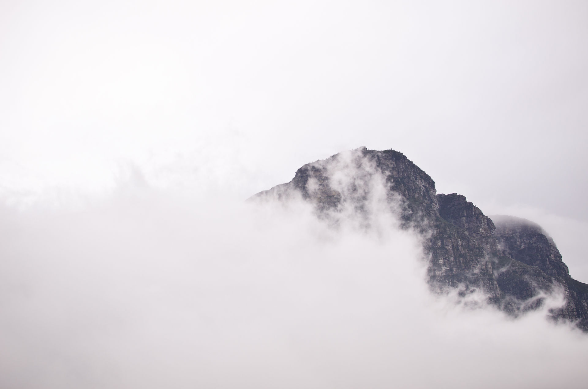
Typically, as I returned to the car and looked back towards the Halti mountain, the clouds had moved higher.

Heading to Helsinki
7th September
This was my final #Nordic peak. It was a massive weight off my shoulders getting these out the way. Sweden and Finland were the last significant obstacles before my planned finale in Russia. I had only the four easy low lands of the Baltic's, and Belarus left. But first, I would fly down to Helsinki and regroup with my friends before my next one in Estonia.


Comments