Peak 1 | Carrauntoohil, Ireland | 1039m | 2nd April 2019
- Adam Stevenson

- Apr 2, 2019
- 5 min read
Updated: Nov 26, 2019
This is where my adventure begins. The first peak in the list of 48 high points across Europe. But we were welcomed in by some harsh weather, where several of my first essential lessons were learned. Mountains can be unpredictable.

Quick Summary
• Starting point - Cronin Farm
• Route taken - Devil's Ladder
• Total ascent - 860 m
• Total length - 12.1 km round trip
• Total time for the climb - 4½ hours
• Expense category - #Low
• Equipment - #StandardHike
• Difficulty - #Level2 of 5
• Enjoyment - #3star of 5*
Here we go...
31st March
Firstly, if you don't know anything about me, the challenge, or what made me do this. Then you should read a little more about it here. In a nutshell, I was asked by a good friend if I wanted to join him on a trip of a lifetime - to climb to the highest point in every European country. It seemed crazy. He then told me he wanted to attempt to beat a Guinness World Record by completing them quicker than anyone had done previously. Without much convincing, I was in. I quit my job, sold my house, and left my family and friends behind for this adventure within just a few short months. And here's my story...

Before we set off on our journey, we went back and forth with where we were going to start this monumental task. We eventually settled with Ireland. So we commenced our road trip by driving from our home town of Chester towards North Wales. From here, we would take a ferry from Holyhead, and across the Irish Sea to Dublin.
We settled into Dublin for the night and headed to the lively musical heart of the city, Temple Bar. Tucked into our first pint of the trip and talked about what lay ahead of us. We were all happy to start soon plotting things we could do, see, and eat in each of the 50 countries that were lined up.
Surprisingly, our trip wasn't planned out as most would expect. We had a route of our first three peaks lined up. After that, I guess we just hoped for some Irish luck. ☘️
Dublin to Killarney
1st April
The next morning we left Dublin to head towards the mountain, visiting Cork on-route. We stayed in the town of Killarney the night before the climb. And excited to get started, we prepared some gear and set up our Garmin In-reach GPS tracking device we had just purchased. As part of our evidence requirements for the record attempt, we needed to collect our location data for the climbs. And this little device soon proved to be worth its weight in gold on the mountains.
The weather didn't look particularly good for the following day. But this is a mountain infamously known for spending the majority of the year shrouded in clouds. So, once again, we headed to one of the local pubs and got out what would become our go-to travel game, Monopoly Deal.
There were a couple of reasons why we chose Carrauntoohil as the first peak in our expedition. Firstly, it's relatively close to home. Therefore, it would give us the chance to test our gear out. And if we then needed additional items that we had forgotten, it could be easily collected before venturing out to mainland Europe.
Climbing the highest point in Ireland
2nd April
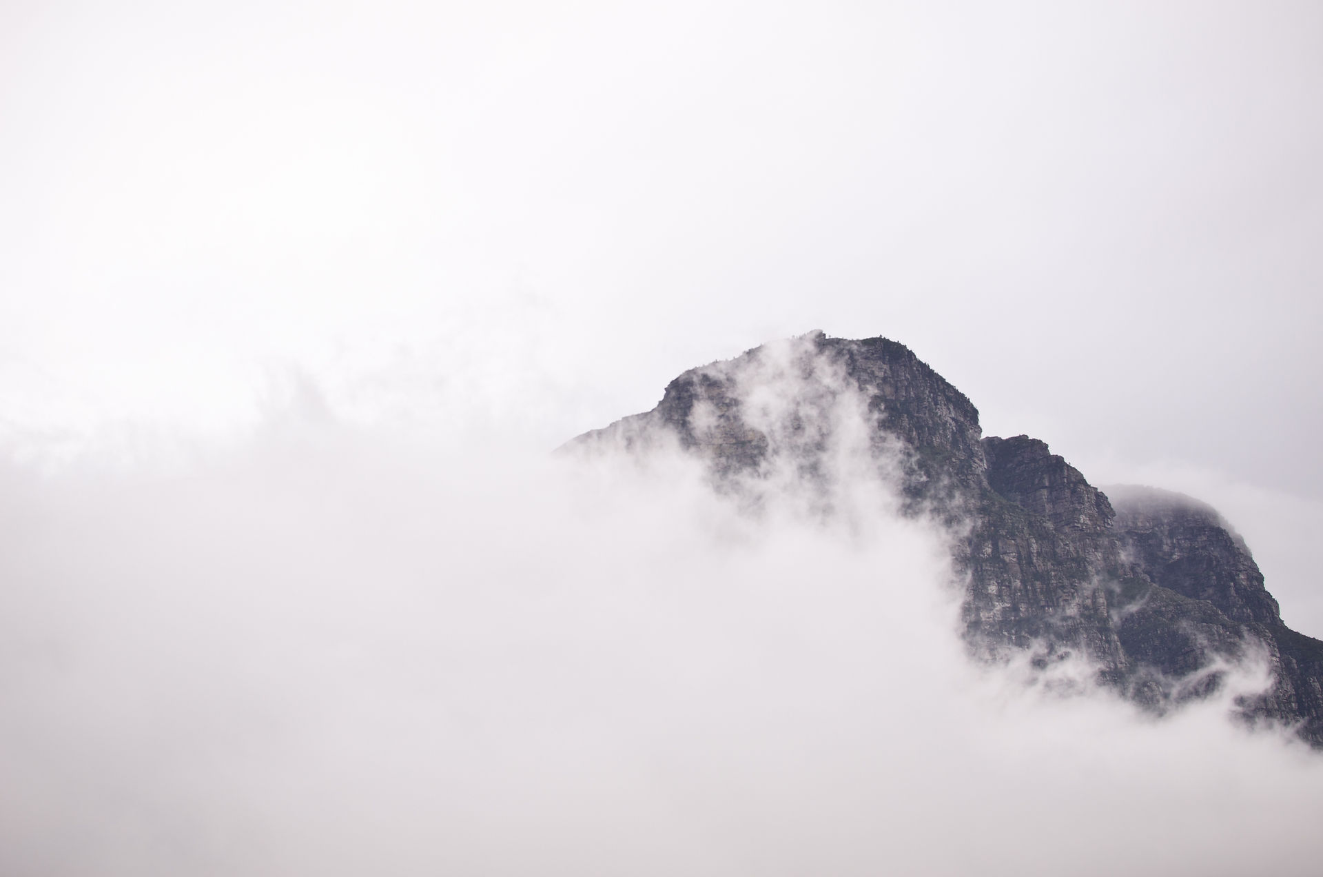
It was summit day, and we were off! However, it didn't take us long to encounter the first error of the climb. I didn't check the starting point before we left, instead I just simply set the navigation to Carrauntoohil. This sent us around the back of the mountain through the Gap of Dunloe and towards the Black Valley. It was a stunning drive following the narrow winding roads between the lakes and mountains. The bad weather made the place look so dramatic and moody, which I loved.

Eventually, we passed some road workers filling in potholes. One explained in the thickest Irish accent that I'd ever heard, that we needed to go back if we wanted to go up Carrauntoohil via the Devils Ladder. We turned around and got on the right road, but ultimately it cost us about an hour.

We eventually arrived at the carpark of Cronins Yard. Here we met two Irish lads that had just come back from the summit. They briefly explained to us where to start the hike and the conditions at the top. We were warned of snow and blizzard-like weather higher up. Stating we would need a bit of luck to reach the summit. The main issue was the viability. The top part of the mountain has no clear trail to follow under the snow.

It was 12:15 pm, and the moment that we left the car and started the hike was the official point that we started the clock on our Guinness World Record attempt.
The first part of the walk was simple, nothing strenuous, and the weather stayed relatively dry for us. However, we still couldn't identify Carrauntoohil due to the cloud cover. Our plan initially was to start the first part of the walk and come back the following day to reach the summit. But upon walking the first hour, we had a clearing in the weather could see the mountain. We decided just to go for it hoping to get there and back before the clouds came back in.

The ascent on this route doesn't really start until reaching the foot of the Devils Ladder. This is a short, steep scramble up a narrow gully filled with loose rocks. It can be dangerous with lot of people on it. But there was only one other group we passed on this section as we ascended it.

After here, we came to the saddle. Where we were perhaps 20 mins away from the top. The summit was shrouded in clouds, and there was now a layer of snow covering the ground. It would have probably have been the sensible option to turn around at this point and come back the following morning where the weather conditions looked more favorable. But the temptation was too high, and we carried on regardless.

We ended up reaching the summit at 2:30 pm, and almost instantaneously, the skies opened up with hail and strong blistering winds. Visibility was reduced further, down to just a few meters by this point. Sensing the importance of getting down quickly. We only stayed long enough to get a few quick photos and a video as our evidence.

But as we started to descend, we encountered the real problem of not being able to distinguish the route where we arrived from. Fresh snow had covered our tracks, and we needed to revert to our Garmin GPS device to confirm our position and direction in the whiteout. In just one use, this piece of kit had proved to me to be invaluable.
Not long after, we found the top of the Devils Ladder, where we dropped below the cloud line again to unveil our surroundings once more.

There were several valuable lessons I took away from our first peak. It became apparent that I needed to up-skill in several areas quickly if I was to do this. Planning needed to be more thought though, and weather conditions need to be taken more seriously.
After getting the first peak in the bag, we traveled to stay the night in Galway before heading onto Belfast the following day. Between now and then, some significant developments happened that threatened the entire project from continuing.
Continue the story - Peak 2 | Slieve Donard, Northern Ireland.
Tags


Comments